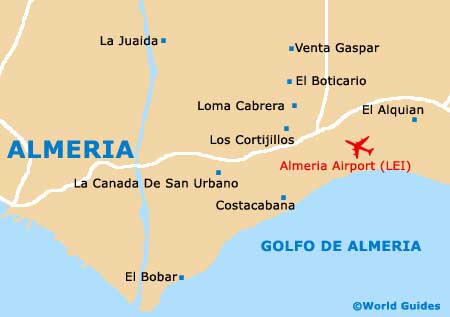
Almeria Airport (LEI)
Orientation and Maps
(Almeria, Spain)
The city of Almeria is situated on the south-eastern coastline of mainland Spain, next to the Mediterranean Sea. Lying just over 160 km / 100 miles to the south-east of Granada, Almeria is close to a number of significant towns, villages and areas.
Notable locations include Gádor, Rioja, Benahadux, Pechina and Huércal de Almeria, all of which lie directly north of Almeria. Other areas of interest include Felix and Vicar to the west, El Ejido and Roquetas De Mar to the south-west, and both El Barranquete and Rambla de Morales to the east, close to the Almeria Airport (LEI) and other attractions.
Almeria Airport (LEI) Maps: Important City Districts
The very heart of Almeria is sandwiched between the Alcazabra area and the Rambla de Belén, a prominent boulevard which was once a riverbed. Almeria's main thoroughfare is the Paseo de Almeria, which joins the Rambla de Belén to the north-west and is intersected by the Puerta de Purchena. Both the bus station and the train station can be found at the Plaza de la Estación, located on the eastern side of the Rambla de Belén.
The Paseo Maritimo is located to the east of central Almeria and is situated in front of the long stretches of grey, sandy beaches. Lined with mature palm trees, the Paseo Maritimo is near to a large selection of hotels and shops.
One of the most popular attractions close to Almeria is the Cabo de Gata Natural Park, which covers a vast area and is full of natural beauty. Highlights here include huge stretches of secluded beaches, nature trails, stunning views and mountainous scenery.
Spain Map

Almeria Map